Roads & PavementRoads & Pavement
Barefoot
Minimal
Low
Medium
High
Maximal
All around running shoes offer comfort and cushioning for daily runs, jogs, walks, and long mileage. They offer enough versatility for both faster and slower runs and are a great option for those who want one running shoe to do it all.
Fast run or uptempo running shoes are lightweight and responsive. They offer streamlined designs that have minimal uppers and offer a high level of energy return. These shoes are a great option for faster runs in the week or those looking for a livelier experience.
Max Cushion shoes offer premium cushioning with ample ground protection and a stable ride. These types of shoes provide abundant impact protection that softens landings while running at any pace or distance. These types of shoes are best for slower recovery runs and easy days where comfort takes priority.
Racing shoes are designed with optimal performance in mind. These types of shoes have snug-fitting uppers, energetic midsole foams, and features implemented for maximum efficiency. These types of shoes are best for runners looking to gain the ultimate advantage in races but may sacrifice some durability and comfort.
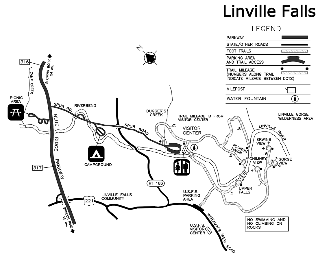
Gym Workout shoes offer a stable and versatile ride. They have a firmer underfoot feeling that provides stability for lateral movements with comfortable uppers. These types of shoes are best for trips to the gyms, cross training, casual wear, and light running. Linville Gorge Trail Linville River Trail to Wolf Pit Road
Road running shoes feature smooth outsoles that are designed for running on paved surfaces such as roads, sidewalks, and bike paths.
Designed to handle most trail runs, these shoes prioritize comfort and a smooth ride. These shoes are great for anything from smooth singletrack, park trails, and fireroads making them ideal for those who run from their doorstep on streets before hitting the trail.
These shoes are best used for hard, rugged trails such as shale, granite or sandstone where grip on smooth surfaces and underfoot protection are important.
Designed for use in muddy, soggy conditions, these shoes feature very aggressive outsoles that dig deep into soft ground for exceptional traction.
These shoes feature technical outsoles designed to grip snowy and icy trails making them ideal for winter trail running.
Cushioning level, or stack height, refers to how much shoe is between your foot and the ground. For this category, we reference the amount of cushioning below the forefoot as the heel height will be equal to or greater than the forefoot height.
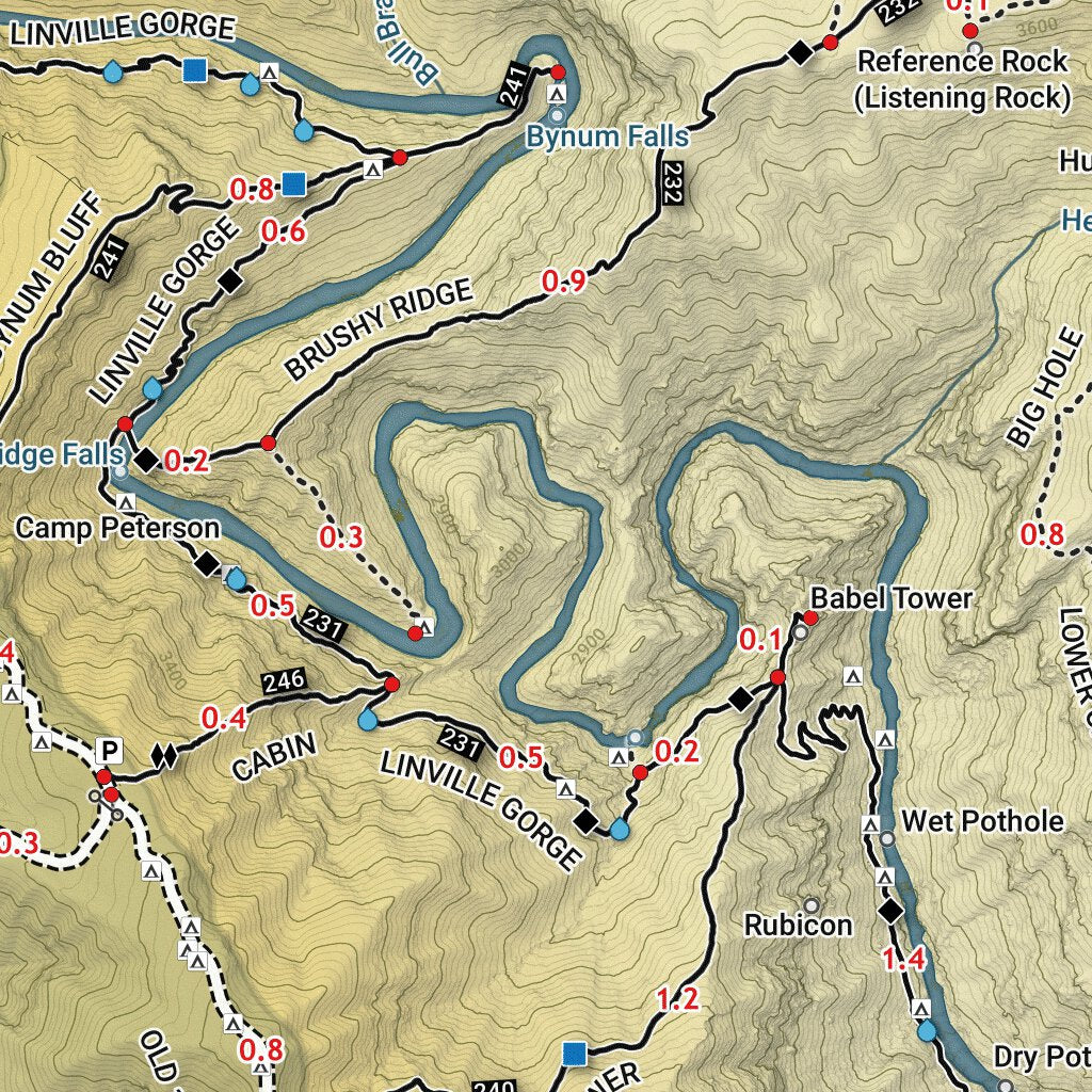
Linville Gorge Wilderness Map by Linville Gorge Maps LGMAPS
0-13mm. The Shoe generally does not have a midsole and feels like there is no cushioning. This shoe is all about feeling the ground underfoot.
14-18mm. The shoe has a thin midsole that allows for a natural running experience. Racing shoes and minimalist shoes are common here. These shoes offer a feeling of being connected to the road or trail.
19-23mm. The shoe has a slightly cushioned feel and may feature added cushioning technologies. Performance training shoes and some trail shoes are common here. These offer protection during footstrike but prioritize a lightweight, grounded experience.
24-28mm. These shoes have a stack height that fall near the middle of the spectrum.The shoes in this category are verstaile and great for all types of runs and distances.
29-34mm. The shoe has a thick midsole and ample cushioning. These shoes are highly protective and absorb more impact than the body.
35mm plus. The shoe has an extremely thick midsole and extra cushioning. The focus is on protection and soft foam underfoot with hardly any ground feel.
Neutral shoes support the foot through a normal range of arch collapse and generally do not have a built-in technology to correct movement.
Stability shoes are a great option for those who overpronate or need added support. These shoes help to limit the inward rolling motion of the ankle while running or walking and assist in guiding the foot straight through the gait cycle. Pix For Linville Gorge Linville gorge Hiking trip North
Product Details:
Linville Falls Blue Ridge Parkway Milepost 316.4 outlet, The Grand Loop Linville Gorge r Ultramarathon outlet, Linville Gorge Mountain Biking Opportunities outlet, Linville Falls Plunge Basin Trail outlet, Linville Gorge Cabin Bynum Bluff Trails 5.0 miles d 7.72 outlet, Segment 4 Mountains to Sea Trail outlet, Sitting Bear Mountain and Shortoff Trail Linville Gorge outlet, Linville Gorge Cabin Bynum Bluff Trails 5.0 miles d 7.72 outlet, Adventures in Pisgah Another Linville Gorge Half Marathon outlet, Map of Linville Gorge Trail McDowell County outlet, Linville Gorge Mount Mitchell Pisgah National Forest Trail Map Nat Geo 779 outlet, Daffodil Flats via Pinnacle MST Leadmine Linville Gorge and outlet, Pisgah Map Company s outlet, 10 Best Hikes and Trails in Linville Gorge Wilderness AllTrails outlet, National Geographic Trails Illustrated Maps Linville Gorge outlet, Linville Gorge Hiking trail info for the Linville Gorge Wilderness outlet, Pisgah National Forest Linville Gorge Wilderness Special Use Map outlet, The Linville Gorge Loop The Trek outlet, Linville Gorge Camping near Table Rock and Hawksbill Mountain outlet, Conley Cove Trail to Linville Gorge Trail North Carolina 108 outlet, Linville Falls in Winter hiking Linville Gorge winter waterfalls outlet, Maps LGMAPS Linville Gorge Maps outlet, Linville Gorge Wilderness Map by Linville Gorge Maps LGMAPS outlet, Linville Gorge Circuit Trail Running route in North Carolina outlet, Linville Gorge North Carolina outlet, Linville Falls Trail Map Picture of Linville Gorge Linville outlet, Linville Caverns outlet, Pinch In Trail and Rock Jock Trail Hike outlet, 2 Days in the Linville Gorge Wilderness MeltzerSeltzer outlet, Linville Gorge Grand Loop North Carolina 340 Reviews Map outlet, The Grand Loop LGMAPS Linville Gorge Maps outlet, 5 Ways to Experience Linville Falls The GloveTrotters outlet, Linville Gorge Wilderness Pisgah National Forest North Carolina outlet, Linville Gorge Loop North Carolina 36 Reviews Map AllTrails outlet, 7 Best Linville Gorge ideas linville gorge gorges north outlet, The LinvilleGorge Trail Map LGMAPS Linville Gorge Maps outlet, Sherpa Guides North Carolina Mountains Linville Falls outlet, Pinch In Trail and Rock Jock Trail Hike outlet, Linville Gorge Sintax77 outlet, The LinvilleGorge Trail Map LGMAPS Linville Gorge Maps outlet, Linville Falls Hiking Trails Blue Ridge Parkway U.S. National outlet, Pix For Linville Gorge Linville gorge Hiking trip North outlet, Linville Gorge Wilderness Map by Linville Gorge Maps LGMAPS outlet, Linville Gorge Trail Linville River Trail to Wolf Pit Road outlet, Not to brag but Linville Gorge Wilderness is giving rugged good outlet, Linville Gorge trails News journalpatriot outlet, Linville Gorge Wilderness Is That All Ya Got Loop North outlet, Sherpa Guides North Carolina Mountains Linville Gorge outlet, Welcome to Linville Gorge LGMAPS Linville Gorge Maps outlet, USFS Linville Gorge Wilderness 2014 LGMAPS Linville Gorge Maps outlet, Product Info:
Linville gorge trail map outlet.
- Increased inherent stability
- Smooth transitions
- All day comfort
Model Number: SKU#7441705